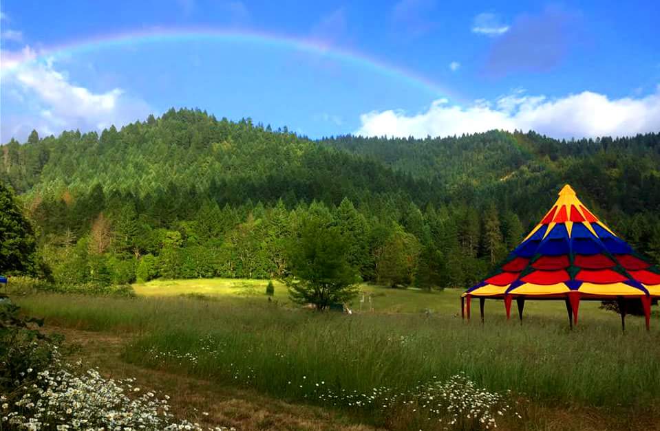
Monday Sept 11. Pendulum gathering will be by Zoom, with people gathering in small pods, Sept 17-19. (Call: bit.ly/PendulumCall2022)
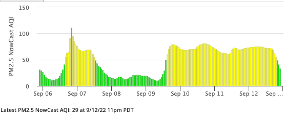
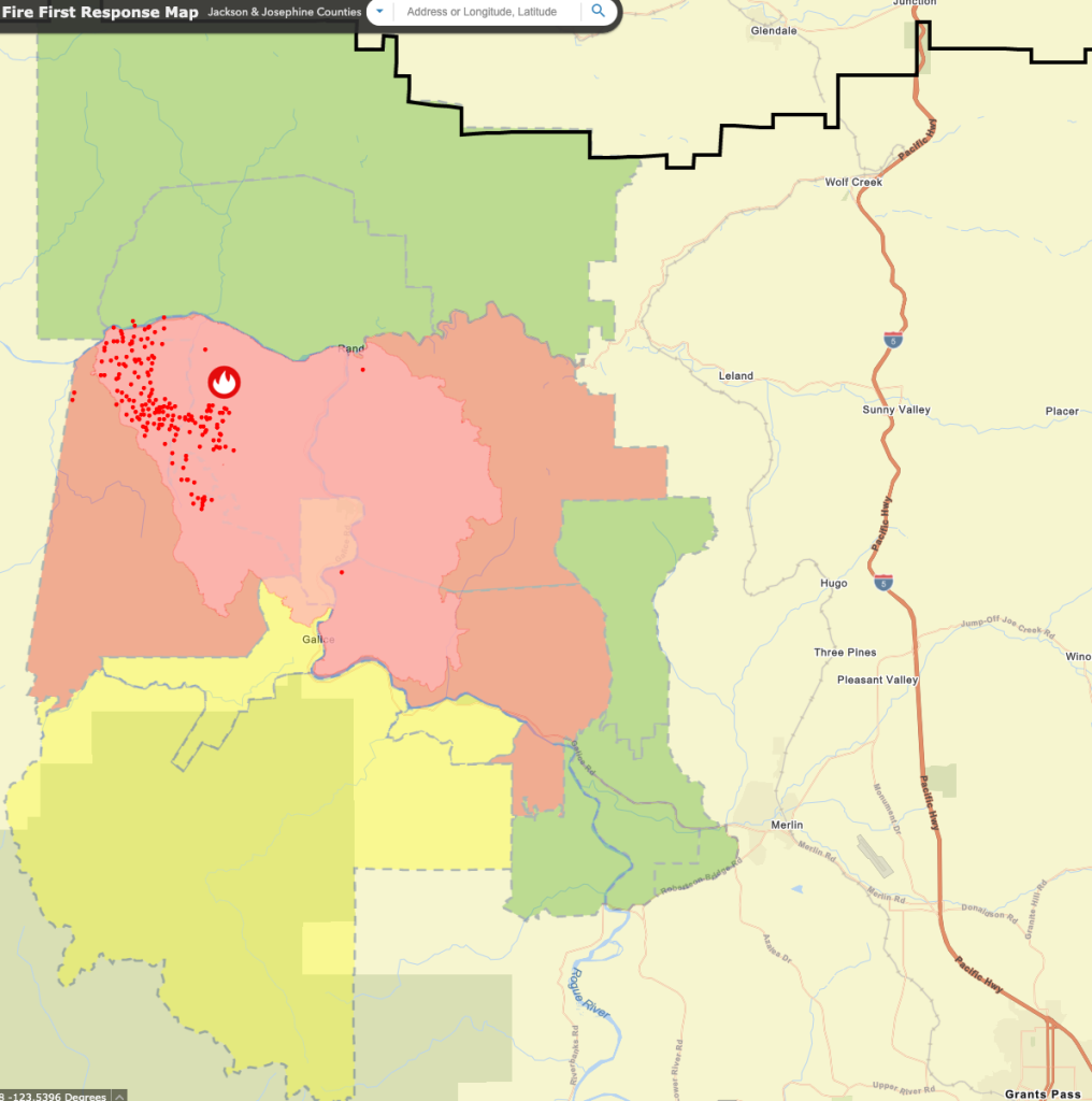
The Rum Creek wildfire is contained, and no longer a threat to the Sanctuary. (Some spots will smolder and burn until winter.) Most smoke is blowing from elsewhere in Oregon, Idaho, and California.
Smoke outlook: “Winds from the northwest will dominate the area moving smoke from the Cedar Creek Fire away from this Outlook area. Communities surrounding the Rum Creek Fire should see improving conditions with more impacts east of the area.”
- Rum Creek fire incident info (NWCC) and map; Facebook page
- Jo Co fire info page
- Smoke map and air quality advisory
- Josephine County fire map (evac zones & live satellite fire info)
- Facebook: Jo Co Emergency Management (has video updates)
- unofficial: Twitter Zeke Lunder – The Lookout (@wildland_zko)

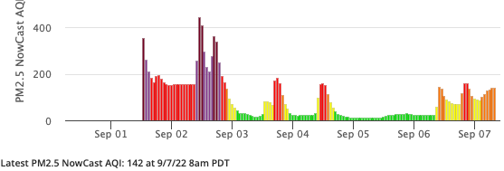
Dark purple: Hazardous (“Avoid all outdoor physical activity. If you are hot, go someplace with air conditioning.”) Purple: Very Unhealthy (“Limit all outdoor physical activity. Go indoors if you have symptoms.”) Red: Unhealthy (“Keep outdoor activities light and short. Go indoors if you have symptoms”) Orange: Unhealthy for Sensitive Groups. Yellow: Moderate/Acceptable. Green: Good.
(For some reason this graph, from the AirNow.gov map, often shows lower numbers than those directly from PurpleAir, where the sensor comes from. Lately, the former shows Moderate while the latter says Unhealthy for Sensitive Groups. Go figure…)
9/11NWCC update: “The Rum Creek Fire has now been tested by several days of critically low relative humidity, high temperatures, and periods of gusty winds. Few flare-ups were reported and no spot fires were found outside the containment lines. Acreage has not changed for two days, and containment has increased to 69% despite the adverse weather… In the interior of the fire, larger fuels like stumps and logs may continue to smolder or burn until they are extinguished by heavy winter rain and snow. Most of the fine fuels near them have burned or will have a higher moisture content, making fire spread unlikely.” Crews are now repairing damage caused by fire fighting, and are working on erosion control.
Air quality can change rapidly with the wind; Friday 9/2 , it went from Moderate to Hazardous in two hours, peaking at 492.

Log
- 8/29 Green evac zone up to Grave Creek Rd and approaching Leland.
- 8/30 am Green evac zone east to I-5, from Wolf Creek through Merlin. Overnight, the fire pushed across the E line (including the Rogue River), burning several hundred acres; expect increase in fire activity thru Fri. Actively burning on ridges. Level 3 / Red zone is residents only, with roadblocks at Galice and Grays Ranch (Grave Ck Rd, 2mi away).
As the crow flies, closest outbreak is 4½ miles away, with the marked fire perimeter 5½ mi. - 8/31 eve: We’re about on the edge between sectors (divisions) “H” and “L”, well back from where the action is. Most firefighters are strengthening the existing fire lines. Fire broke through in places on the east side, about midway N-S; crews are looking good to get those enclosed.
- 9/1 am: “Firefighters continue to concentrate on the east side of Rum Creek Fire, focusing on areas of slop-over from Tuesday evening. Yesterday and overnight, crews established new fire lines and cooled its edge, keeping the fire from spreading further east… The fire is burning actively in the McKnabe Creek drainage, and firefighters intend to initiate line construction in this area today. Firefighters and dozers are also working south from Grave Creek, preparing fire lines for a tactical firing in the coming days… More of the structural resources are shifting to the east of the fire to assess structures and do pre-planning and structure preparation in case the fire pushes in that direction. After the inversion lifts today, the fire is expected to burn actively due to high temperatures and low relative humidity. On Friday afternoon or evening, a dry cold front will move through the area. While this will bring slightly cooler temperatures, the front is also expected to bring gusty winds from the northwest. Fire personnel will be monitoring the weather closely and watching for wind-driven flare-ups.”
“The Oregon Department of Environmental Quality extended an air quality advisory Thursday for Curry, Jackson and Josephine counties due to intermittent periods of heavy smoke from the Rum Creek Fire expected in the area for the foreseeable future.” - 9/1 eve (video update): They’re using backfires to reinforce the lines in several sectors. Monitoring closely for spread in tonight’s winds. Red Flag weather expected Friday.
- 9/2 “IR mapping shows the Rum Creek Fire at 16,583 acres, growing 1,643 acres since Thursday. Firefighters are concentrating on the east side of the fire, focusing on areas most susceptible to critical fire weather conditions. A dry cold front will move through the area late Friday into overnight Saturday. Higher winds aligning with peak fire activity may produce spotting and increased growth. Lower temperatures and higher humidity will moderate fire behavior of the weekend.”
Air quality: “Heaviest smoke will remain in the immediate vicinity of the fire – including Galice, Merlin, Glendale, Cayonville, and Riddle. Moderate-to-heavy smoke will continue into the Illinois Valley, Applegate Valley, and Rogue River Valley until the dry cold front arrives overnight Friday. Widespread clearing will bring much needed relief to the area by tomorrow. “
NWCC afternoon update: “Today a Red Flag Warning is in effect from 11am to 11pm. NOAA issues this warning for the Rum Creek Fire and other parts of southern Oregon for strong gusty winds and low relative humidity. Forecasters expect passage of a dry cold front this afternoon or evening.”
At 3pm, air quality at Wolf Creek is Hazardous: PM2.5 is 465. (“Everyone should avoid any outdoor activity.”) Everything is very dry. Smoke hangs heavily on the hills and meadow. - 9/5 NWCC morning update: “Tomorrow’s weather will provide a test for the fire lines. If the fire stays within the current footprint, fire managers can be more confident that it will not escape the fire lines in the future. Rum Creek Fire will be under a Haines 6 tomorrow, the highest level on the index, indicating the greatest potential for rapid fire growth. Also, the National Weather Service has issued a Fire Weather Watch for Tuesday afternoon and evening for the Rum Creek Fire area. The forecast calls for high temperatures, gusty winds and low relative humidity.
The Haines Index is a tool used to estimate the effect of atmospheric dryness and stability on fire growth potential. When the atmosphere is unstable, windy conditions allow mixing of air near the ground with air higher in the atmosphere. This mixing provides ample fresh air flow to a fire, allowing it to burn freely and potentially grow rapidly and develop a smoke plume. These conditions are more likely to allow a fire to run or spot past fire lines.”
Air quality: “Today, heaviest smoke impacts from the Rum Creek Fire will be in the immediate vicinity of the fire perimeter and along the Illinois Valley. Increased heat and wind Tuesday will disperse widespread smoke but may produce additional smoke into Wednesday.” - 9/6 NWCC morning update: “The National Weather Service has issued a Red Flag Warning for Tuesday afternoon and evening for the Rum Creek Fire area. A Red Flag Warning means that critical fire weather conditions are either occurring now or will shortly. The forecast calls for high temperatures, gusty winds and low relative humidity. These conditions may cause a fire to flare up, and promote rapid spread of fire… Firefighters are mopping up, adding depth along the edges, as time permits to reduce the chance of fire escaping.
ODF Tuesday 8pm update: A Heat Advisory extends until 11pm Wednesday, with more hot weather expected later in the week… With high temperatures, low relative humidity, and some gusty winds, the fire burned actively today. Except for a few spot first on the northwest part, the fire stayed within the containment lines.
Air quality: “As drying, warming, and gusty winds persist through the week, new smoke will be dependent on fire behavior and containment of the fire perimeter.” - Wolf Creek air now is Acceptable. This can change rapidly with the wind; on Friday, it went from Moderate to Hazardous in two hours, peaking at 492.
- Josephine Co announcement 12:30pm: Level 1 – BE READY downgraded for the following areas: North of Lower Grave Creek Road… INCLUDES Wolf Creek, Leland, Hugo, Three Pines, and Merlin Areas
- NWCC morning update: “Despite the heat and rugged terrain, firefighters on the Rum Creek Fire continue to make progress. Containment has increased to 42%, with most edges of the fire mopped up at least 75 feet inside fire lines… Overnight, the fire stayed within the containment lines despite high temperatures, low relative humidity and gusty winds. Today, temperatures will continue to be high, triggering a Heat Advisory from the National Weather Service… A few isolated storm cells are passing through the area today, bringing scattered lightning and minimal rain. NWS has issued a Fire Weather Watch for Thursday afternoon and evening, for strong gusty winds and low relative humidity.”
- A Heat Advisory extends until 11pm Wednesday, with more hot weather expected later in the week.
- Air quality, Jos Co Wed 8pm: “Smoke and haze from several fires in the region as well as farther away, will continue to contribute to local conditions. Haze concentrations for the Illinois Valley will move back toward Merlin and Galice areas by the morning, and then towards Medford and Ashland later tomorrow. Larger incidents to the north and east of Josephine County will also add to the local Rum Creek fire smoke.”
- Air quality: “Low laying clouds will delay smoke lifting until this afternoon. Smoke will move southwest, bringing widespread smoke to the Applegate Valley, Illinois Valley, and coastal locations. Overnight, areas of heaviest impacts will be in the immediate vicinity of the fire perimeter, including Galice and Western Merlin. Tomorrow, smoke will move westward. This pattern continues into Friday, bringing heavier smoke from Cedar Creek and out-of-state fires into the forecast region.”
- Heat advisory until 11pm Wednesday: High temperatures of 100 to 106 are expected in the valleys, and in the 90s over most mountain areas, except areas above 6000 feet elevation.
- 9/7 Josephine Co announcement 12:30pm: Level 1 – BE READY downgraded for the following areas: North of Lower Grave Creek Road… INCLUDES Wolf Creek, Leland, Hugo, Three Pines, and Merlin Areas
- NWCC morning update: “Despite the heat and rugged terrain, firefighters on the Rum Creek Fire continue to make progress. Containment has increased to 42%, with most edges of the fire mopped up at least 75 feet inside fire lines… Overnight, the fire stayed within the containment lines despite high temperatures, low relative humidity and gusty winds. Today, temperatures will continue to be high, triggering a Heat Advisory from the National Weather Service… A few isolated storm cells are passing through the area today, bringing scattered lightning and minimal rain. NWS has issued a Fire Weather Watch for Thursday afternoon and evening, for strong gusty winds and low relative humidity.”
- A Heat Advisory extends until 11pm Wednesday, with more hot weather expected later in the week.
- Air quality, Jos Co Wed 8pm: “Smoke and haze from several fires in the region as well as farther away, will continue to contribute to local conditions. Haze concentrations for the Illinois Valley will move back toward Merlin and Galice areas by the morning, and then towards Medford and Ashland later tomorrow. Larger incidents to the north and east of Josephine County will also add to the local Rum Creek fire smoke.”
- Air quality: “Low laying clouds will delay smoke lifting until this afternoon. Smoke will move southwest, bringing widespread smoke to the Applegate Valley, Illinois Valley, and coastal locations. Overnight, areas of heaviest impacts will be in the immediate vicinity of the fire perimeter, including Galice and Western Merlin. Tomorrow, smoke will move westward. This pattern continues into Friday, bringing heavier smoke from Cedar Creek and out-of-state fires into the forecast region.”


Air quality can change rapidly with the wind; Friday 9/2 , it went from Moderate to Hazardous in two hours, peaking at 492.
